Saturday, July 26, 2014

Guhagar: 

Guhagar is situated on west coast of india. Guhagar is a census city in Ratnagiri district in the Indian state of Maharashtra. The guhagar is known for its virgin beach, coir items, coconuts, betel nuts and mainly Haapus Alphanso mangoes. The nearest city and railhead is Chiplun, about 44 kilometres (27 mi) away. The economy of Guhagar boomed after the Dabhol Power Company, a few kilometres north was commissioned in the early 1990s.

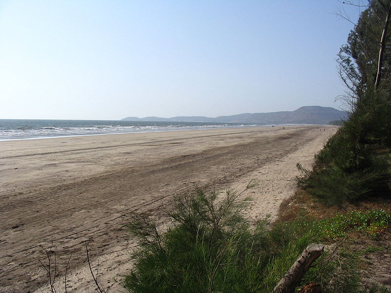
A word GUHAGAR means cave house in local language. Guhagar is a scenic town with hilly terrain. It is even called a temple town. To name few, Ancient hindu temple of Vyadeshwar , temple of durgadevi, temple of Lord Ganesh or Kopri Narayan mandir . Guhagar beach (about 6 kilometer long ) is one of the main tourist destination, and is a unique places to enjoy Konkani culture. Long lonely beach with silky white sand is a perfect getaway to rural tourism. This uncontaminated and secluded virgin beach is simply addictive to almost all the people visiting this small town.

Comprising of waterfalls, mountains, spectacular sunset view on beach, temple and lush green valley during monsoon season Guhagar offers you splendid traveling experience.


How to reach at Guhagar:

By Road:


The best way to get in is by road. Maharashtra State Transport (S.T.) buses ply from Mumbai, Thane and Pune. The S.T. Bus depot is right in the heart of Guhagar Town.

Chiplun is the nearest major city and is directly on NH17. The state highway turning off to the right when approaching Chiplun from Mumbai on NH17 leads to Guhagar which is approximately 40 KM away.

Pune to Guhagar : People travelling from Pune can reach Guhagar by traveling to Satara on NH4 and then to Patan, Koayana Nagar and then by descending Kumbharli Ghat to reach Chiplun and finally Guhagar.

Pune to Guhagar : 288 kms

Pune -> Shirval -> Patan -> Koynanagar -> Chiplun -> Guhagar 

Mumbai to Guhagar: 320 kms

Mumbai -> Vashi -> Panvel -> Pen -> Wadkhal -> Kolad -> Mangaon -> Mahad -> Poladpur -> Khed -> Chiplun -> Guhagar

Ganapatipule to Guhagar:  190 kms

Ganpatipule -> Bhatgaon -> Rai bridge -> Welamb -> Shrungartali -> Guhagar


By Train: 

Nearest Railway station is Chiplun railway station in the Konkal railway region. It is connected to Mumbai and Goa. From the railway station to Guhagar is about 40 km.


Places to Visit near Guhagar:


Vyadeshwar - 
This temple of Lord Shiva is literally a stone's throw away from the S.T. Depot, right in the middle of the bazaar. It is the Kuladaivat of a lot of Kokanastha Chitpavan Brahmins (Surnames like Patwardhan,Godbole, Damle, Oak, Phadke, Apte, Abhyankar, Soman, Bhat, Ranade, Joglekar, Agashe, Kelkar, Deodhar, Pethe, Gadre). The Main Pujari at this temple is Bhave Guruji.


Ufarata Ganpati - This temple of Lord Ganesha is 200 metres away from Bazaar, on the road to Anjanvel/Veldoor. The idol is carved in white stone (marble?) and was found by local fishermen around 300 years back. There is a legend associated with this idol, that's worth taking a note.

Guhagar Beach - 
Guhagar beach is one of the cleanest and less polluted beaches in Maharashtra. It is located just within 200 metres from Guhagar S.T. Depot towards west. The beach looks pretty safe though there are warnings posted by local villagers. Off late, Chat stalls have started making business on the shore.

Velaneshwar - Approximately 25 KM south of Guhagar, along Guhagar-Hedvi road, is located this beautiful temple of Lord Shiva. The temple is right on the pristine sea shore. Just like Vyadeshwar, this too is Kuladaivat of lots of Kokanastha Chitpavan Brahmins. (Surnames like Gokhale, Raste, Dev, Gadgil, Tulpule). There are smaller temples of other gods like Shri Vishnu, Ganesha, Kalabhairav around the main temple. At the entrance is located a tall Deepamaal.

Hedvi - Hedvi is a small village located at approximately 27KM along Guhagar-Narvan road, towards south of Guhagar. This small vilalge is yet another popular location around Guhagar that boasts of 2 places worth seeing. Most famous is the temple of Dashabhuja (10 Hands) Ganapati. This temple dates back to age of Peshwas. The idol of lord Ganesha is carved in marble and is supposed to be from Jammu-Kashmir. The temple is recently renovated and is very clean and simple. The second place is around 3 KM away from the temple, by the sea side, called Brahman Ghal (Gorge). On the same sea shore is the temple of Uma Maheshwari. One has to go past this temple to reach the Brahman Ghal. This beautiful natural wonder is a gorge in the black rock patch and is around 20 feet deep, 35 feet long and 1-2 feet wide in dimensions. During the high tide, the sea water gushes in and splashes around.

Budhal - The sea shore of Budhal has both kinds to offer - serenity and danger. This small town is located around 5 KM from Village Adoor Phata along Guhagar Hedvi Road. The town is scantily populated - hardly 40 houses. The approach road is pretty bad and terminates at a spot that offers commanding view of the entire Budhal village and the rough rocky sea shore it has. One can also see a small temple and a virgin beach of yellow sand past the village.

Chandika Mandir - Chandika Mandir is located around 15 KM north of Guhagar. One has to travel to Veldoor ( 10 KM away from Guhagar) and cross the Dabhol creek by launch to reach Harbor Dabhol on the north side. From Dabhol the Chandika Mandir approach road is around 4 KM when traveling towards Dapoli. The temple is 15-20 feet under ground in a cave. Electricity is forbidden inside and hence only source of lighting is lamps and candles lit. The idol of Goddess Chandika is swayambhoo (self-borne) and supposed to be from the ages of Pandava. However, it was discovered only 300 years back. Outside the temple is a tomb of the discoverer of this temple.

Enron Project - 
Along Guhagar - Veldoor road, near Anjanvel is this controversial project of electricity generation from gas. One can see 70-80% of this project while traveling along the road.

Gopalgad - This ancient fort is located near Anjanvel - 11 KM North of Guhagar, along the coast line. It is believed to be built at the start of 16th Century by the Siddis. It was captured by Shivaji Maharah in 1660. What remains today is only the ruins of this huge fort that spans 7 Acres of land.

Read More

Thursday, March 13, 2014

Tarkarli Beach:

Tarkarli is one of the best and most safe beach of coastal Maharashtra, also called Kokan. The beach has flat table land which can accommodate 5-6 football grounds ! Very safe to swim and play group water games. Tarkarli is a small beach side village in Taluka Malvan, Sindhudurg Destrict. You will find that almost every alternate local home has started lodging and boarding facilities.

 Tarkarli is one of the most amazing beaches in the Konkan region. A beautiful beach to spend time with both friends & family surrounded with plenty of hotels & home stays.  The majestic Sindhudurg fort can be sighted from this fabulous beach. Overall, this beach is gorgeous. It's secluded, sunny and perfect for an entire day of just lazing around, playing frisbee, drinking cold and soul-wrenchingly good solkadhi, and a good game of frisbee. Tarkarli is 8 km south of Malvan and 546 km from Mumbai on the west coast of India, at the confluence of the Karli River and the Arabian Sea.

How to reach at Tarkarli Beach:


•         By Air: 

Nearest airport is Dabolim Airport in Goa.
•         By Rail: Following options exist:
•         Sindhudurg, but all trains don't stop there and also connectivity by means of bus and rickshaw are not very good.
•         Kudal on the Konkan Railway. This is around 1 hour 15 minutes by road from Malvan. Buses are available from and to Malvan after every 30 minutes. Frequency is slow in the evening. If you want to go to tarkali directly, taxis and rickshaws are available from kudal station east, 700rs for taxi after a bit of bargaining. (November rate 2012) Takes you directly to tarkali beach road where you can find accommodation by asking the cab driver to stop for couple of minutes
.•         Kankavli on the Konkan Railway. This is around 1 hour 30 minutes by road from Malvan. Buses are available from and to Malvan after every 30 minutes. Frequency is slow in the evening.


•         By Road: 

Tarkarli is easily accessible from Malvan by bus and rickshaw. Tarkarli is 475 KM (Panvel Kochi Road, NH 17) and 576 KM (Mumbai Kohlapur Road NH 4) away from Mumbai. Daily private, luxury and State Transport bus service available from various parts of Goa, Mumbai, Pune to Malvan.

Places to Visit near Tarkarli Beach:


  1. Sindhudurg Fort 
  2. Malvan Market
  3. Sangam
  4. Nivati Beach
  5. Golden Rock
  6. Rock Garden at Malwan
  7. Malvan Plateau

 Adventure Sports on Tarkarli Beach:

 1.    Snorkeling ( to see corals and fishes )
2.    Scuba diving
3.    Scuba Diving and Snorkeling
4.    Boating
5.    white water rafting

You can hire an entire boat. It will take you for dolphin seeing, golden rocks, tsunami island (for water sports) and snorkelling if you wish even if you don't know how to swim, they have floats.


Read More

Tuesday, September 4, 2012


         Kashid beach is a good weekend gateaway. Kashid beach is located in the North Konkan region of Maharashtra. It is located 30 km from Alibag and 135 km from Mumbai on the Alibag-Murud road.


            Kashid Beach is a favourite destination for beach seekers who do not wish to travel as far as Goa. There are a number of shacks by the beach that have hammocks so that you can rest in the shade and sip coconut water when the afternoon sun gets too hot to bask in.
            Kashid is famous for its white sand, blue seas, green mountains, paddy fields, and rivulets. Kashid has a 3 km stretch of beach tucked in between two rocky hillocks with Casuarina groves all around the seashore.


         The waves here are unusually high and can be paradise for surfing. The waves can reach a height 5–6 feet even during the non-monsoon months. However it is dangerously high during the monsoons and surfing is not recommending during the months of June to September.

Getting there:

The road access is very good:

160 km from Mumbai
135 km from Thane
110 km from Navi Mumbai (Vashi)
170 km from Pune (via Mulshi)
Around 170-180 km from Pune (via Khopoli - Mumbai Pune Expressway)

Buses:
Buses plying regularly between Mumbai central - Murud halts at Kashid
Buses plying regularly between Thane - Murud halts at Kashid
Frequent service are available for Alibaug from Mumbai, Thane. From there buses are available for Murud which halts at Kashid village
Read More

Friday, June 22, 2012


                       Harihareshwar is a town in Raigad district, in Maharashtra, India from where the river Savitri enters the Arabian Sea. It is famous for a temple on the seashore as well as the beach and the natural beauties. The Harihareshwar temple built in the 16th century with the dieties of Vishnu Brahma and Shiva and was re-constructed by First Bajirao Peshawa in 1723. The secondary attraction in Harihareshwar is beautiful stretch of beach. Beach is not very safe for swimming especially during low tide. It has lots of undercurrents.


                     Harihareshwar is bordered on one side by the Bankot creek, and on the other side by the Arabian Sea. The Bankot is the confluence of the Savitri River and ocean. A beautiful cypress grove adds greenness to the seaside environs. The town is surrounded by four holy hills, which represent Visnu, Brahma, Siva, and Parvati: Harihareshwar, Harshinachal, Bramhadri, and Pushpadri.
Harihareshwar is often referred to as Dev-ghar, or 'House of God', because the temple sits to the north and is said to have been blessed by Lord Vishnu. The sacred River Savitri enters the sea from Harihareshwar.


Getting there:

By Air: Nearest Airport is Mumbai, 215 Kms
By Rail: Nearest railhead is Mangaon on Konkan railways
By Road:

Mumbai to Harihareshwar Distance: 230 Kms
Mumbai to Harihareshwar Road Map:
Mumbai > Panvel > (Goa Highway) Nagothane> Vadkal Naka > Mahad > Mangaon > (Exit Goa Highway by turning right)> Mhasala> Shriwardhan > Harihareshwar

Pune to Harihareshwar Disatance: 175 Kms
Pune to Harihareshwar Road Map:
Pune > Mulshi > Tamini Ghats> Vile> Mangaon > Mhasala> Shriwardhan > Harihareshwar
Six seater rickshaws, taxis and private buses are available from Shreevardhan.
If you are coming from South, best way to take is from Khed on Mumbai-Goa highway via Khed-Mandangad-Veshvi-Bankot.

Shrivardhan – Harihareshwar, 20 Kms
Bagmandala – Harihareshwar, 4 Kms...

Read More

Sunday, March 25, 2012


Alibag or Alibaug (Marathi: अलिबाग) or Alibagh (Hindi: अलीबाग़) is a coastal town and a municipal council in Raigad District in the Konkan region of Maharashtra, India. It is also the headquarters of the Raigad district.
Alibag is surrounded by sea on all 3 sides, it is often called as the Goa of Maharashtra
Shivaji's naval chief Kanhoji Angre developed Alibag in the 17th century. It is not only a sun city but also an amazing weekend location. The city shot into prominence after Chatrapati Shivaji Maharaj built the fort of Kulaba.


Fixed in the lap of nature, Alibag is a maritime town of India. The town is renowned for its clean waters, sand like beaches and fresh air. Alibag is an astonishingly beautiful place and nature appears to be at its best. Alibag is placed on the southern tip of Mumbai, on the constrict strip of Arabian Sea.

Alibag is a tropical island with all trees and palm lacunae beaches. The various orchards and chikoo trees have made the place an unpolluted spot. It is particularly fantastic during the rainy season.


Beaches around Alibag:
Beaches The following are the main beaches in and around Alibag:
  • Alibag beach: This is the main beach of the town.
  • Alibag Fort: Alibag is the seat of District Administration of Raigad (formerly Kolaba) district since 1852. The name Kolaba is attributed to a Sea Fort Kolaba built by Shivaji the great, in 1680 to fight the mighty naval prowess of the Siddis' (Abyssenians) of Janjira and the British of Mumbai. Kolaba fort is famous for many battles, between Siddis and Kanhoji Angre, the British and the Portuguese.
  • THAL beach: Isolated Beach 5 km from Alibag.
  • Varsoli Beach:Located about a mile from the main beach, home to a very large naval base.It is situated just on the outskirts of Alibag. It is relatively less visited site and as a result is a quiet beach with sparkling white sand and cleaner seawater. Varsoli is a small satellite village across Alibag, complete with thick vegetation of coconut and Casuarina.
  • Akshi Beach: It is situated 6kms away from Alibag.The famous Kashid beach is located 18 km from Murud. The specialty of this beach is the beautiful slivery white sand. literally dazzling silvery on this clean beach. It is a favourite spot for advertising, TV serial and film shoots. The beach is complete with small-food stalls. This beach is well suited for the children and ladies as the sea is flat for a long distance. One can walk through to a considerable distance towards the sea.
  • Nagaon beach: It is situated about 10 km away from Alibag and is famous for coconuts and betel nuts.
  • Kihim-Navgaon Beach: Kihim is a secluded place at a distance of 12 km from Alibag. The Kihim beach is famous for dense cover of Coconut trees. It is also famous for woods which are home to rare butterflies, birds and flowers.
  • Awas: It is situated about 16 km away from Alibag.
  • Saswane: It is situated about 18 km away from Alibag.
  • Rewas: It is situated about 24 km away from Alibag.
  • Chaul Revdanda: It is situated about 17 km away from Alibag.
  • Kaneshwar Mandir: It is situated about 17 km away from Alibag to Karlekhind - Chondi road.13 km from Alibag in Northeast direction is this very famous Shiv temple on a 900 ft. high hill. It is a 5000 ft. long climb on well paved stairs, which takes around one hour. Landmarks along the route are tombs of MohanGiri and Balgiri, Nagoba Rest, Jambhali Plateau, God's stair, Gaymandi etc. The fatigue of the uphill climb vanishes the moment one enters the scenic temple premises . It comprises various small temples of Sri Paleshwar, Sri Hanuman, Sri Balram Krishna and Lord Shiv. The special attraction is an ancient sweet water tank enclosed in traditional structure of black stone. The ancient temple was built by Raja Ramdeorai yadav. The height of the Shiv temple is 54 ft. The front gate has Lion sculpture on both sides with traditional lamp-pillar(deepmaal) in front. The 4 ft. long 'Pindi' of Lord Shiv is silver plated. The premises also include Nagaar-khana, Bheem Kunda, a garden for flowers to be offered to the Lord, Sri Ram Ganesh temple and Gomukha. Every year, there is a fair on Kartik Poornima in Hindu calender. On this hill, a variety of herbs are found.
  • Mandawa: It is situated about 20 km north of Alibag. The catamaran/ferry services are available from Mumbai to the Mandawa jetty. Many Bollywood celebrities own bungalows here.
  • Kashid Beach: It is 36 km away from Alibag, on the Alibag-Murud highway, also this beach is possibly one of the cleanest and most beautiful beaches in the region with almost 'white' sand. There are many cottages and resorts available ranging from around RS:1500 to RS:20,000. Prakruti resort is the luxury and the costliest of all. This village does not have any wine shops. One has to go around 6 km towards Murud to buy alcohol. Kashid is the perfect place to calm down and relax for the urban people. One can find water sports facility and number of small shops for snacks. BEWARE: Take care of your self in the water (particularly at the high tides) as there were many incidents which cost the life. There is a danger board warning the people.
  • Korlai Beach: A quiet serene beach with alternate white and black sands, along a serene stretch of the Arabian coastine, adjacent to a village of Korlai Creole Portuguese speaking Indians. Just across the bridge, to the right there is Korlai fort within the sea and attached to the mainland by a narrow land strip through the Korlao fort through the Korlai Village. It is supposed to have been built by the Portuguese in 1521. The main gate has an inscription which means 'no entry without a fight'. The fort has seven gates, a sweet water well, a church in disuse, a Hindu temple and a Lighthouse.


Getting There:

Mumbai               93Km
Pune 140Km
Hyderabad 698Km
Nagpur 907Km
Bangalore 982Km

By boat:
There are ferries and catamarans available from the Gateway of India, Mumbai. The journey takes 2 hours. However, service is suspended during the rains, i.e. May-October. The ferry takes you to Rewas and you are taken on a bus to Alibag. The cost of the bus trip is usually included in the ferry fare. This is the recommended way of getting to Alibag.
By bus
  • MSRTC buses should be available from various parts of Maharashtra. If you are leaving from Mumbai, then you have an option of boarding MSRTC buses, leaving every 30 mins - 1 hr from the Mumbai Central Bus Station. Though they might be uncomfortable, they top in terms of punctuality. Remember to grab a window seat!
  • Private buses can be chartered - a good option if you are going in a large group.
By car
  • Take a car or a taxi from Mumbai. Alibag is on the way to Goa from Mumbai, so you could do the trip as part of a trip down south to Goa. To reach Alibag from Mumbai, take the Mumbai-Goa-Ernakulam National Highway (NH17). At Wadkhal 'naka'(crossing), which is a little 8 km ahead of Pen, continue straight (the left turn keeps you on the highway to Goa), and you are now on the road to Alibag! Alibag is about 22 km from that point!
  • From Pune, take the Mumbai-Pune Expressway and take the Khopoli exit. From there drive towards Pen (30 km), then cross Mumbai-Goa highway to proceed towards Alibag.
By train
Alibag is not served by the Central Railway. The nearest Central Railway stations are very far - Panvel, 85 km away and Roha, 50 km away.
By bike
  • Take a car or a taxi from Mumbai. Alibag is on the way to Goa from Mumbai, so you could do the trip as part of a trip down south to Goa. To reach Alibag from Mumbai, take the Mumbai-Goa-Ernakulam National Highway (NH17). At Wadkhal 'naka'(crossing), which is a little 8 km ahead of Pen, continue straight (the left turn keeps you on the highway to Goa), and you are now on the road to Alibag! Alibag is about 22 km from that point!
  • From Pune, take the Mumbai-Pune Expressway and take the Khopoli exit. From there drive towards Pen (30 km), then cross Mumbai-Goa highway to proceed towards Alibag.

Read More

Thursday, February 9, 2012

             Diveagar Beach is located approximately 170 kilometers south of Mumbai. The beach is accessible from the Mumbai-Goa highway (via Kolad or Karnala).

            A beach that shot up in popularity after a serendipitous discovery of a golden mask of the elephant god Ganesha, Diveagar is a small village in the Raigad district. With a long stretch of black sand beach and a village full of beetle nuts, jack fruits and banana plantains Diveagar has a ver fresh feel about it. The access to the Diveagar beach is covered with 'Belu' plants and looks like a fence of the beach!


             Diveagar beach is or approximately six kilometers long. At one end of the beach is a fishing settlement, while the other end has a sanctuary of migratory seagulls.
            The beach contains a number of Suru trees, which are common to coastal Maharashtra. The access to the beach has a dense cover of Belu trees, which are otherwise uncommon in the area.
            Another major attraction in Diveagar village is a temple of Lord Ganesh. The idol has a mask which is made of pure gold. This mask was discovered by Mrs Patil, a few decades back buried along with other treasure in a thick copper trunk in her beetel farm, opposite Abhynkar's House.

Diveagar has numerous households offering accommodation for as low as Rs.300-400 per day. The local cuisines are worth exploring & better enjoy eating it as no other options are available. Diveagar is an ideal weekend getaway away from City crowd. Don’t expect any luxury hotels & typical city eating joints here but be prepared to be surprised by the simplicity & calmness offered by this place.
 
Diveagar is a popular beach destination along with nearby towns of Shrivardhan Origin of the Peshwas and Harihareshwar.
Sand Bubble Crabs can be found on the beach and at nearby Harihareshwar one can find Dolphins.
 
Getting There
Via Tamhini ghat (approx 200 km)
• Pune — Paud – Pirangut Road — Tamhini Ghat — Turn left at Vile
• Vile — Nijampur — Mangaon .You will reach NH – 17. Continue traveling left towards Mahad
• Turn right 500 mts after Mangaon ST Stand on SH 97 to Mhasala. Turn right again on SH98 after Mhasala – Arathi Road Junction – Shrivardhan
(Road map: Pune – Chandani Chauk – Paud – Mulshi – Dongarwadi – Tamhini Ghat – Vile – Nijampur – Mangaon – Lonere Phata – Goregaon – Mhasala – Arathi Road Junction – Shrivardhan. Road is smooth and good. It could be bad for portion of the ghat section. Avoid crossing Tamhini Ghat after 6:00 PM. It is not safe)
Via Mahabaleshwar (235 km)
• Pune — Pune – Bangalore Highway — Surur Village
• Turn right towards Wai — Panchgani — Mahabaleshwar — Ambenali Ghat — Poladpur.
• You will reach NH17 at Poladpur.
• Turn right towards Mahad – Lonere Phata – Goregaon
• Goregaon – Mhasala – Arathi Road Junction – Shrivardhan (SH 98)
(Road map via Mahabaleshwar: Pune – Shirval – surur – Wai – Panchgani – Mahabaleshwar – Poladpur – Mahad – Goregaon – Mhasala – Arathi Road Junction – Shrivardhan. Road is smooth and very good. It is 4 lane toll road (NH4) till surur village (first 80 KMs). Ghat section is also good and safe to cross even in the night as it is crowded with Mahabaleshwar bound traffic.)
Via Bhor (185 km)
• Pune — Pune – Bangalore Highway NH4 — Khed Shivapur
• Turn right just ahead of Khed Shivapur at Bhor Phata
• Bhor — Varandha Ghat — reach NH – 17 at "Hotel Sagar" just outside Mahad.
• Turn right towards Mangaon. Get off the highway at Lonere Phata to Goregaon – Mhasala – Shrivardhan. (SH 98)
(Road map via Bhor: Pune – Khed Shivapur – Bhor – Varandha Ghat – Mahad – Goregaon – Mhasala – Shrivardhan). Road is 4 lane toll road till Khed Shivapur. After that it is not in good shape. Do not cross Varandha Ghat during night as it is not very safe. This is shortest distance to reach Mahad from Pune but road is not that smooth. If you have good 4 wheeler like Scoirpio, Supo, Safari, you may even opt for this route.)
Read More

Wednesday, October 12, 2011

                     Raigad (Marathi:रायगड) is a hill fortress situated in the modern day Raigad district of Maharashtra, India. The Maratha king Shivaji Maharaj made the fort his capital in 1674 when he was crowned King of a Maratha Kingdom which later developed into the Maratha Empire eventually covering majority of modern day India. It was the capital of King Chhatrapati Shivaji Maharaj because according to him the fort was so terrifying & difficult as no blade of grass grows on completely vertical rock. British has also defined the fort Raigad as ‘The Gibraltar of East'.                  

 "Fort Raigad is much more than a mere tourist spot. It is a sacred place of pilgrimage, which has left an imprint of the grand vision of Hindavi Swarajya as cherished by Chhatrapati Shivaji Maharaj."
                  

                  The fort, which rises 820 metres (2,700 ft) above sea level, is located in the Sahyadri mountain range. There are approximately 1400–1450 steps leading to the fort, though today a rope-way exists to reach the top of the fort. The fort was looted and destroyed by the British upon siege.

        Trekking: There are many interesting routes to Raigad, varying from the relatively easyto the challenging. The path starts from Pachad, 24 kms from Mahad, a shallowseaport on the banks of the Savitri River. Raigad can also be anadventure-filled day excursion from the hill station of Mahabaleshwar or fromPune.
              At the foothills near village Pachad, is Chit Darwaja, also known as Jit Darwaja. After gruelling foot-slogging, you reach Khoob Ladha Buruj. It is a strategically located turret, from where an aggressor attacking from either flank could be repelled. Nearly a mile ahead, after a difficult climb comes the Maha Darwaja. Built over 350 years ago, this main entrance to the Fort stands majestically. It is as imposing and stout today, as it was then! The design of this Maha Darwaja is an enigma. It defies detection of its location to the attacker. Blind curves enroute make it impossible for the attacker to use elephants to knock it down. In the battle of those historic times, elephants were used to demolish fort entrances.

                    A steep climb of nearly 1450 steps and three and a half hours of extreme demands on your physical stamina, leaves you too exhausted. The magic mantra - Raigad Ropeway - has opened a new chapter of sightseeing - the Fort Raigad. It whisks you to the top, through the clouds and whistling winds, in just 4 minutes. Gone is its exhausting inaccessibility. Now you have all the energy and time to enjoy the sightseeing! Well-trained and courteous guides are at hand to give you a conducted tour of the Fort.

               The Ropeway lands you at the top of the fort near Mena Darwaja. This was the special entrance for the royal ladies and the queens. To the left of Mena Darwaja is the Rani Vasa or "Queens' Chambers". They are six in number and were being used by the mother of Shiv Chhatrapati - Jeeja Mata, Soyarabai, Putalabai and other royal ladies.


             In front of the Rani Vasa is the Palkhi Darwaja. A special entrance for the convoy of Shivaji Maharaj. On the right side of Mena Darwaja, is the office complex of 8 principal secretaries of Shivaji Maharaj. To the right of Palkhi Darwaja, there is a row of three dark chambers. Historians believe that these were the granaries for the fort.
            To the right of the granaries is the palace of Shivaji Maharaj. It is called the Raj Bhavan, where he dispensed justice in petty and routine matters. The palace rests on a double plinth and had wooden columns to support the palatial structure. The Raj Bhavan is a mute witness to the joys, sorrows, anger, victories and overwhelming generosity of Shiv Chhatrapati. The plinth adjoining Raj Bhavan, holds two large water tanks and by its side, is the location of the Royal Bath. Excellent toilet and drainage system highlights the structural design of that era. To the east of Raj Bhavan is in an open space, there is an underground cellar. It was used for secret dialogues, worshipping Bhavani Mata and for storing war booty after the raid on Surat.


               The fort has many huge water reservoirs, one of which is the picturesque Ganga Sagar. Two main entrances from the Royal Palace open in to a sprawling lawn. This is the Raj Sabha. It has witnessed the splendour of the glorious coronation of Shiv Chhatrapati. The shackles of 300 years of slavery were broken and Shivaji Maharaj proclaimed establishment of Hindavi Swarajya! The magnificent throne, studded with diamonds and gold, rested on eight columns of pure gold weighing almost 1000 kilos. It also bears the royal emblem of Shivaji Maharaj. The umbrella over the throne was adorned with strings of precious stones and pearls.


              Entry for common public to Raj Sabha was through the Nagarkhana. In those times, the royal band played here round the clock. It is an excellent example of architecture and miraculous acoustics. The distance between 'Nagarkhana and the Royal Throne is more than 200 feet, yet even the slightest whisper can be heard from both ends very clearly.


              Holi Cha Mal, is outside the Nagarkhana. It is a wide open ground, used for annual Holi festival. There is a temple of Shirkai Bhavani, a presiding deity of the Fort. In front of Holi Cha Mal, there is a spacious and well laid-out marketplace. It is built on a high plinth and is separated by a 40-foot wide road leading to the Jagadishwar Temple. Adjacent to this temple, is the most revered place on Fort Raigad, the Samadhi of Shiv Chhatrapati. The Samadhi is intact and well-maintained, even today, due to the personal initiative of Lokmanya Bal Gangadhar Tilak.

                  Other places of interest are ammunition depot, Bara Tanki i.e. more than a dozen huge water reservoirs, Rameshwar Mandir, Wagh Darwaja, Takmak Tok - an execution place for the proclaimed criminals, etc. These are testimony to the valour, courage and ultimate sacrifice of Maratha soldiers, who made Hindavi Swarajya a reality.

Read More

Recent News